
It’s that time of year when the mountains are being shut down for the winter and our family is cramming in as many adventures as we can before that happens. No more overnight tent camping for us until spring. For our final summer adventure this year, we went to the Magruder Corridor. I have always wanted to go, but my husband likes being in his comfort zone and only like places he has been to before. I was able to convince him this year, to try and change it up more, so we went to the Magruder Corridor. It was a last-minute decision made the night before to went, and we spontaneously changed our plans.
The Magruder Corridor provides an array of activities. Besides driving this historical road (preferably a high clearance vehicle or atvs), the nearby Selway River is a great place for fishing, rafting, and kayaking. For anglers, this area of the Selway is catch-and-release only. Also, the Selway River at times is categorized anywhere from a level four to a level seven for white water rafting. Be awarof current guidelines and restrictions, which you can check at the West Fork Rangers Station. Permits are needed to float the River at certain times of the year and an Idaho fishing license is required. This area also is a treasure trove for horsemen, hikers and mountain bikers and there are multiple trails that you can access from the main road. A great resource that I used this year, was the OnX Offroad App, the shows every trail and road, as well as the types of access for those trails.

This place is amazing. It is a historical road and trail. The Magruder Corridor is about 120 miles long and runs from Darby, MT to Elk City, ID. There are multiple historical sites along the road, and we didn’t get to see them all, but we were able to see quite a few. We were able to combine history with outdoor activities so I was pretty happy. What’s unique about this road is that not only does it have tons of historical value; it is also located in two wilderness areas, the Frank Church- River of No Return and the Selway-Bitterroot as well as being in two states, Montana and Idaho. Only 2% of the lower 48 states is designated wilderness area. This means that the land is left in its primeval state and is pretty much untouched by civilization.

Before we left on our adventure, we printed out the brochure that I found online https://www.fs.usda.gov/Internet/FSE_DOCUMENTS/fsm91_055707.pdf and also printed out a map. There are no services and no cell phone signal, which is just the way we like it. Normally, you have to hike into the majority of wilderness areas, but this time we were able to car camp instead of backpacking and we also took our Polaris Rzrs for some off-roading fun. I packed everything up the night before so we were ready to get going the next day without having to rush.
On the way to our campsite on Friday afternoon, we passed several of the locations listed in the brochure and stopped at some but not all. We started off on the Montana side and took the Painted Rocks State Park turnoff. On the way, we passed by the West Fork Ranger Station but did not stop because it was after hours. The turn-off for Magruder is before you get to Painted Rocks. We saw multiple elk and mule deer along the road but we didn’t take pictures because the animals were grazing by people’s houses and we didn’t want to infringe. The pavement ends and you hit a dirt road, and then its pavement again. According to the brochure, portions of the road were paved due to potential logging back in the seventies, but logging was stopped by the passing of the Wilderness Act. There are some cool vintage signs along the way and two large campgrounds, Little West Fork and Fales Flat. At the top of the pass, we stopped at the lookout. The elevation is 6598 feet and the view is breath-taking with the mountains going on forever. There are also some really good informational signs and a map.


We did not stop at Hell’s Half Acre Lookout Tower or Deep Creek Campground, but I did stop to take a photo of the stone water fountain at the CCC Camp. There is not a lot left in these areas due to forest fires. Multiple forest fires have affected this area, but it’s part of the current fire policy to let it burn without suppression efforts. It’s considered healthy forest management.


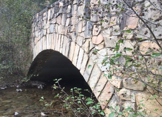
Our next stop was the Deep Creek Bridge, a stone bridge hand-cut by Lithuanian masons in the 1930’s. The stone is native and it’s a gorgeous piece of art, arching over the Selway River. If you go over the bridge, it’s just a little ways to the Magruder Ranger Station which is currently left vacant but if you’re not a camper, you can rent the cabin for about $50.00 per night and it sleeps ten. There are multiple log buildings in a large clearing, a wooden bridge that crosses the river and a hiking trail. In 2013, the station almost burned down due to a forest fire. A lot of the buildings and bridges were built by the CCC (the Civilian Conservation Corps) in the 30’s.

Finding a camping spot was extremely easy. We found a nice little spot by the Selway River, with a fire ring and an outhouse, located at the Raven Creek Campground, found on the turn off for Paradise which is aptly named with a spectacular view. Paradise is popular for floaters, fishermen and hunters. There are multiple camping areas every couple of miles and most with outhouses all along the Magruder Corridor. Our spot was right off the road and close to the river so the kids could fish. Our toddler had a blast throwing rocks in the water which was very shallow. A lot of the other camp sites were full of outfitters due to hunting season, so we got lucky that this one was empty.
We set up our camp and cooked a yummy tri-tip roast over the fire with s’mores for dessert. We made sure everything was bear-proof and there was no food left out to attract wildlife. The kids went to bed and Al and I had an ice-cold beer by the fire before heading to out tent. No hammock camping this time, it was too cold.


The next morning, we got up early and enjoyed listening to the birds and river while eating hot oatmeal for breakfast and drinking cocoa. After cleaning up, we headed out on our RZRs for some off-roading. There are multiple signs reminding drivers to stay on the road which we always follow because following the rules is part of what keeps these areas open. We made sure we had lunch and plenty of water (see Got Helmet? 6 Tips For Off-Roading)and headed out for the day.
The first historical point we came across that day was the Magruder Crossing Bridge, the only bridge you can drive over in the upper Selway. This gorgeous, sky-blue steel bridge was also built in the 1930’s. We stopped on it on our way there and again on our way back. I can only imagine how hard it was to build it without a crane or modern machinery. Further up the road at the top of a mountain, we stopped at the Magruder Massacre information sign. Magruder Corridor is named after Lloyd Magruder, a wealthy business man who was murdered in 1864, then his body was burned and thrown off of a cliff. Montana and Idaho definitely have a colorful history typical of the Old West.


There was a turn off with a view of a lake called Gold Pan Lake. There is a slight trail, but it looks like it will be bush-wacking all of the way down. The whole area was covered with tamaracks (also known as larch trees), a deciduous tree that its needles change to yellow and orange in the fall. There are several hiking trails at Salmon Mountain and Salmon Observation Point and those views are breath-taking as well, but there were people camped there so we avoided stopping. For the next trip.
At Horse Heaven, we got out and explored the primitive cabin. This cabin can also be rented through the forest service and we are thinking about renting either that one or the cabin at the Magruder Ranger Station next year. The cabin is tucked back off of the road in a forested clearing and has a hiking trail close by as well as an outhouse. I have never seen so many toilets while camping, ever. This cabin sleeps four and is very quaint, definitely a step-up from roughing it in a tent.

Our final stop was Dry Saddle Trailhead, with an elevation of 7920 feet. We ate lunch looking out over the wilderness and then turned around. There is a gravel parking lot and pit toilets there is you need to stop, as well as a nice place to eat lunch and take in the gorgeous view. If you plan on going to Elk City, it’s definitely a two-day trip with camping overnight or, there are accommodations at Red River Hot Springs. On the way back, we encountered a moose that would not get off the road!!! That’s typical Montana traffic for you.

We got back to our camp site and let the toddler fish for a little bit until he lost his hook. Don’t forget, if you choose to fish, it is wise to get both a Montana and an Idaho fishing license. We ate hobo dinners for supper and got everything packed away so we could leave early the next day. I’m glad we had everything ready because we woke up Sunday morning to snow!!!! On the way back home, we stopped again at the top of Nez Pierce pass but it was raining pretty hard. Before we got home and because it’s a tradition, we stopped and had breakfast at a local diner. Ever since the first time we went camping, we always stop to eat at some local diner on the way home.
Update 9/2/19: We went back again this year for Labor Day Weekend. The kids and I took a drive up to the Hell’s Half Acre fore tower. The views are phenomenal and it was a quick drive and a little tricky in spots. I would recommend only using atvs or a vehicle with high clearance, because the road is narrow and windy, and rocky in some places. We also stopped at the Paradise Boat Launch, which is was pretty neat seeing how high the river gets in the spring (over six feet from where it is now).
I am so glad that we picked this new spot for our last summer trip. My girls were happy that it was just more than camping this time and loved matching the sites to the stories on the brochure. The scenery is gorgeous and unique and the historical sites are awesome. If you’re ever headed up this way, definitely check it out. There’s plenty to see and lots of options for everyone.


Carole Dickson
Good Job, Pauline. You make it sound so fun and exciting. You have a gift for writing, for sure!! Your photos are awesome too. Pip and I are excited to go up there, soon. Thanks for the info.
admin
I am glad you enjoyed it. Thank you so much.
Tera Elliott
This was a fun post! All the pictures are great and it looked like you all had so much fun!
admin
I have known it was up there for years but we have never gone until now. It’s only about an hour and a half from our house.
Trisha
Wow! That looks like a beautiful place to visit. I’ll have to add it to my list!
Christy White
Our family is hoping to move to Washington or Oregon in the next year. We are going to have to visit this area! Can’t wait!!
admin
Montana’s part of the Rockies are amazing!